One hundred fifty-eighth in an alphabetical series on West Kootenay/Boundary place names
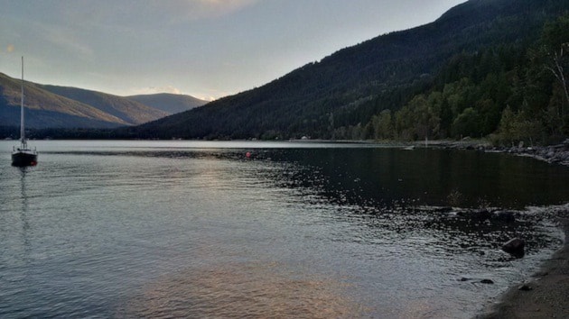
According to Kootenay Outlet Reflections, Queens Bay on Kootenay Lake “received its name before 1883, when the Ainsworth Mining Camp opened.”
However, the earliest known reference is from 1889, in George Dawson’s Report on a Portion of the West Kootanie [sic] District, British Columbia: “The West Arm of Kootanie Lake, from its outlet, extends about nine miles and a half north-eastward, beyond which it turns to an east-north-east direction, when it opens, at Queen’s Bay, on the main lake.”
In British Columbia Place Names, G.P.V. and Helen Akrigg wrote: “Among the names that must be called ‘honorific’ is that of Queens Bay … Encountering this name, one asks what queens may have had this bay named after them. The answer is that, despite the plural form, Queens Bay was named after just one queen, the great Victoria — originally it was Queen’s Bay.”
The Akriggs explained that in 1890, the United States established its Board of Geographic Names which arbitrarily decided geographical names must not contain apostrophes. When the Geographic Board of Canada was formed in 1897, it followed suit.
The Akriggs credited Queen Victoria as the namesake based on a 1969 letter from Nelson librarian Mrs. G.M. Stockell, who stated: “At the turn of the century, there was a great land sale in Great Britain for this area. Many British people came out to settle there and the bay was named after Queen Victoria.”
Indeed, Queens Bay was home to many English settlers who tried their hand at fruit ranching — but as we’ve seen, the name preceded their arrival. Nevertheless, the name did likely honour Queen Victoria (1819-1901). The Queens Bay post office operated from 1909 to 1964.
The upper portion of the neighborhood, including Hamilton Dr., Fisher Ave., Lake St., and Lauder Rd., is often referred to as the Queens Bay townsite. However, it doesn’t appear to have been surveyed as a townsite or marketed as such.
Rambler
This railway siding about 13 km east of New Denver was named after the Rambler-Cariboo mine, staked in 1892. The siding was on the CPR timetable by September 1914 and an early newspaper mention is in the Phoenix Pioneer of Oct. 2, 1915: “The ore will be hauled from the Last Chance tram terminal into Sandon and loaded into cars there for the seven mile railway haul to Rambler siding.”
Don Blake wrote in Valley of the Ghosts: “Rambler Siding was not actually considered a town even though there were towns of much less size than Rambler.”
A late mention is in the Slocan Enterprise of July 3, 1929: “There is also an aerial tramway on the property, connecting the mine with Rambler Siding on the Crowsnest line …”
Rambler no longer exists, but there’s still a Rambler Creek which flows into Dardanelles Creek, south of the headwaters of the Kaslo River.
Raspberry
According to Jon Kalmakoff’s Doukhobor Gazetteer, this Castlegar suburb was established by Doukhobor settlers. It was originally called Malinvoye, which means raspberry in Russian, after a communal plantation. In 1932, a brick village was built there.
However, following the financial collapse of the Christian Community of Universal Brotherhood a few years later, the village’s orchards and buildings were sold privately. Subdivision began in 1962. The former communal homes are still standing — until the early 1990s, one was Raspberry Lodge, a long-term care facility.
There is some debate about the dividing line between Raspberry and Robson. (For purposes of the census and improvement district, they’ve been unofficially amalgamated as Robson-Raspberry. We’ll look at Robson separately in this series.)
Homes on Raspberry, Wild Rose, Bayview, and Parkside roads plus Princess Crescent, all east of the mouth of Pass Creek, are definitely in Raspberry, while the original Robson townsite is well to the west, bounded by Waldie and Charleston avenues.
But what about the area around the former communal village, including Marshall, Waters, Knob, Daye, Redbirch, Colview, and Hilldale roads? It depends who you ask. Nearby Johnny’s Grocery is home to the Robson post office and the Lion’s Head Pub is usually said to be in Robson. The old Robson ferry landing was also there.
To add more confusion, the area along Relkoff Road, to the west of Pass Creek, was once called Strawberry. The name still appeared in the phone book in the 1970s, but has all but disappeared. It’s not recognized by the BC Geographical Names website.
And while Raspberry and Brilliant are distinct places, the old Brilliant school, built in 1934 and now privately owned, was also called Raspberry school.
Below: The old Doukhobor village at Raspberry is seen in 2002. The building on the left was once part of Raspberry Lodge. (Greg Nesteroff photo)

Previous installments in this series
Applegrove, Appleby, and Appledale revisited
Bakers, Birds, and Bosun Landing
Bannock City, Basin City, and Bear Lake City
Bealby Point (aka Florence Park) revisited
Boswell, Bosworth, Boulder Mill, and Broadwater
Brooklyn, Brouse, and Burnt Flat
Camborne, Cariboo City, and Carrolls Landing
Carmi, Cedar Point, Circle City, and Clark’s Camp
Carson, Carstens, and Cascade City
Christina City and Christian Valley
Cody and Champion Creek revisited
Champion Creek revisited, again
Columbia City, Columbia Gardens, and Columbia Park
Crawford Bay and Comaplix revisited
Dawson, Deadwood, and Deanshaven
English Cove and English Point
Forslund, Fosthall, and Fairview
Fort Shepherd vs. Fort Sheppard, Part 1
Fort Shepherd vs. Fort Sheppard, Part 2
Gladstone and Gerrard, revisited
Hall Siding and Healy’s Landing
Hudu Valley, Huntingtdon, and Healy’s Landing revisited
Inonoaklin Valley (aka Fire Valley)
Jersey, Johnsons Landing, and Jubilee Point
Kootenay Bay, Kraft, and Krestova
Kuskonook (and Kuskanax), Part 3
Labarthe, Lafferty, and Longbeach
Makinsons Landing and Marblehead
McDonalds Landing, McGuigan, and Meadow Creek
Meadows, Melville, and Miles’ Ferry
Mirror Lake and Molly Gibson Landing
Montgomery and Monte Carlo, Part 1
Montgomery and Monte Carlo, Part 2