Ninety-first in an alphabetical series on West Kootenay/Boundary place names
Having spent the last three weeks looking into the origins of Howser, we backtrack a bit to examine where the name Duncan came from. In addition to being a lake, river, mountain, glacier, and dam, it’s the Howser townsite’s original name.
On David Thompson’s map of 1812, the Kootenay River is shown as McGillivray’s River and the mountains along its upper reaches are called Duncan’s Mountains. They were named for Duncan McGillivray (1770-1808), an explorer and fur trader who accompanied Thompson.
However, whether the river takes its name from McGillivray is debatable.
The earliest mention of both Howser Creek and the Duncan River is in George M. Dawson’s The Mineral Wealth of British Columbia, published in the 1887-88 Annual Report of the Geological & Natural History Survey of Canada. Dawson wrote: “‘Howser Creek: On this and another stream tributary to Duncan River, which flows into the north end of upper Kootenie [sic] Lake, coarse gold has been found.”
Another early mention, by gold commissioner Gilbert Malcolm Sproat, appeared in the Victoria Daily Colonist of Aug. 31, 1888: “The valleys of the Lardo, northwesterly from the head of Kootenay Lake, and of Duncan River, which heads up towards the mountains south of Roger’s Pass, probably contain mineral-bearing formations …”
Replying to an inquiry from the Geographic Survey of Canada in 1905, Howser postmaster William Simpson wrote: “The Duncan River was named after old Jack Duncan, an old-time prospector in this section. He has been dead some years now.”
According to Canadian Mountain Place Names, “John Duncan was an early prospector in southern BC who spent many years working claims in the vicinity of the lake and lower reaches of the river that now bear his name.”
John Duncan did exist: he was a member of the Ainsworth party that staked the No. 1 mine and testified at the Robert Sproule murder trial in 1885. A note on the BC Geographical Names website says he was “a candidate for the legislative council from Kootenay district, 1866; died ca. 1900.”
The Vancouver Daily World of Aug. 5, 1890 reveals: “John Duncan, who received $8,000 in cash for his mining interests in the Warm Springs district, left Ainsworth on Tuesday for Birkenhead, Cheshire, England, where he has a wife and 14 children. Mr. Duncan does not intend to return to America [sic], claiming that ‘the old country’ is good enough for him.”
In the May 1891 edition of the Alpine Journal, mountaineer Harold W. Topham of the Alpine Club of England stated that he, a friend, and two Swiss climbers named the Duncan Glacier after the river.
What’s now Duncan Lake had several earlier names: it was called Ecclesion on Father Pierre-Jean De Smet’s 1846 map of Oregon Territory and Upper Kootenay Lake on an 1865 map by Walter Moberly, James Turnbull, and A.H. Green as well as J.W. Trutch’s 1871 map of BC.
It’s first called Howser Lake in the Nelson Miner of July 4, 1891, then Hauser Lake in the Miner on Dec. 31, 1892; and Houser Lake in the Tribune of April 20, 1893.
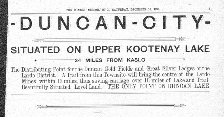
It’s labelled Howser Lake on John Retallack’s 1893 map of the town of Lardo, but first called Duncan Lake in the Miner of Dec. 10, 1892 and on Perry’s Mining Map of 1893. Over the next few years, maps go back and forth on the name, sometimes indicating “Duncan or Howser Lake.”
In 1902 that the Geographic Board of Canada formally adopted Duncan Lake, but it took another decade for government maps to reflect this, and for many more years it was still known interchangeably as Howser Lake.
Previous installments in this series
Applegrove, Appleby, and Appledale revisited
Bakers, Birds, and Bosun Landing
Bannock City, Basin City, and Bear Lake City
Bealby Point (aka Florence Park) revisited
Boswell, Bosworth, Boulder Mill, and Broadwater
Brooklyn, Brouse, and Burnt Flat
Camborne, Cariboo City, and Carrolls Landing
Carmi, Cedar Point, Circle City, and Clark’s Camp
Carson, Carstens, and Cascade City
Christina City and Christian Valley
Cody and Champion Creek revisited
Champion Creek revisited, again
Columbia City, Columbia Gardens, and Columbia Park
Crawford Bay and Comaplix revisited
Dawson, Deadwood, and Deanshaven
English Cove and English Point
Forslund, Fosthall, and Fairview
Fort Shepherd vs. Fort Sheppard, Part 1
Fort Shepherd vs. Fort Sheppard, Part 2
Gladstone and Gerrard, revisited
Granite Siding and Granite City