A new report on the Johnsons Landing landslide recommends restrictions on further development in the community and that residents who choose to still live there understand the risk.
The Regional District of Central Kootenay commissioned the risk assessment report, released to the public yesterday, to understand what caused the massive landslide in July 2012, how likely such an event is to occur again and what can be done to reduce risk to residents.
Geotechnical analysis of the landslide site revealed that record rainfall and the late snowmelt last spring had saturated soils on the slope above the community and triggered the landslide. An event of similar size has not occurred in the area since the glaciers receded some 12,000 years ago.
The landslide killed four people and destroyed five homes. One other home was damaged.
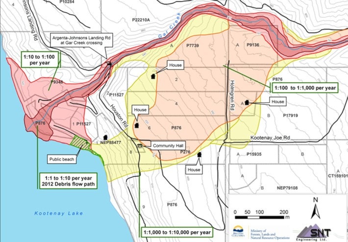
In assessing the ongoing risk to residents, the report considers the likelihood of death from future landslides. The probabilities assume that a resident is in their home when the event occurs.
For the people living at four properties in the moderate hazard zone, there is a 1:1,000 to 1:10,000 per year chance of dying in a landslide. In other words, they’re more likely to die in a landslide this year than in a car accident, which is considered a 1:11,000 risk per year according to Statistics Canada.
In the high hazard area of Johnsons Landing, where there are nine homes, the risk is 1:100 to 1:1,000 per year, meaning occupants in those homes would be more likely to die in a landslide than all other causes combined (Statistics Canada puts the risk of death by any cause —health, accident, etc. at 1:1,000 per year for people over the age of 30).
Finally, there are five properties in the very high hazard area where the chance of dying in a landslide is 1:10 to 1:100.
 “The quantitative risk analysis indicates the risk to some individuals living on the Johnsons Landing bench is unacceptable (higher than typical published acceptability criteria),” the report says, noting typically anything higher than 1:10,000 is considered unacceptable.
Constructing a berm along the edge of the creek may help reduce the risk, as could landslide monitoring programs and teaching residents to recognize the early warning signs of slope instability.
The report made eight recommendations (see right).
In a statement to media, RDCK general manager of corporate administration Dawn Attorp said people living in the highest hazard zones have been informed of that fact.
“They understand the level of risk to their particular properties and to themselves,” she said.
There are currently still 16 residents whose houses were either damaged beyond use, have no access to their house, or are still under evacuation order.
“It’s going to take some time for the RDCK to fully review all recommendations and to develop any possible land-use restrictions based on results from the report,” she said. “We still have a considerable process ahead of us before we can lift the evacuation order for the landslide area and take the next steps in supporting the community in its recovery.”
An open house will be held in Argenta on tonight to share the report findings with Johnsons Landing residents.
The full report is included below.