Thirty-ninth in a series on West Kootenay/Boundary place names
Comaplix is one of the few First Nations names still on the local map — but it hasn’t always recognized as one.
The northeast arm of Upper Arrow Lake was once home to a Sinixt village called nk’mapeleks, meaning “head of lake,” although its precise location is uncertain.
Explorer James Turnbull, who travelled through the area in 1865, referred to the valley as Ill-com-oplaux while engineer Walter Moberly called it Incumappleux. Gilbert Malcolm Sproat, writing in his 1884 Report of Kootenay Country, referred to the Nin-com-ap-a-lux arm.

By 1897, the anglicized version Incomappleux (also spelled Incomapleux and Incommapleux) was applied to the body of water that flowed into the lake, although it was also commonly known as the Fish River.
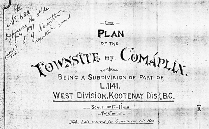
Compalix is another Anglicization of the same word — although its spelling led some sources to mistakenly believe it was of French origin.
The Revelstoke Herald of June 8, 1901 dismissed this notion: “The little town of Comaplix derives its somewhat bizarre appellation from the Indian name of Fish River …”
The first reference to the Comaplix townsite, although not by name, was in Revelstoke’s Kootenay Mail of August 8, 1896: “J.A. Magee of the Kootenay Lumber Co. has a crew of men engaged in clearing a new townsite at the mouth of Fish Creek.”
Thomas H. Parr surveyed the townsite on the north side of the northeast arm on June 21, 1897. The avenues were Osoyoos, Slocan, Kootenay, Okanagan, and Chemainus, and the streets were Water, Front, Main, Cedar, and Pine. Lardeau and Somenos streets were subsequently added.
An application for a post office was filed on February 4, 1897 (the earliest use of Comaplix), but for some reason it didn’t open. The Revelstoke Herald of February 27, 1897 said: “The sawmill on the Arm is soon to get a post office to be known as Comapie [sic].” (It took the Herald until April 3 to get the name right.)
Following a second application, the post office opened on December 15, 1899 and closed July 15, 1915.
Comaplix flourished as a sawmilling town until a suspicious fire levelled the mill, town, and SS Revelstoke in 1915. No one lived there by the time the area was flooded by construction of the Hugh Keenleyside dam. The now-abandoned spot is accessible mainly by boat and is home to one of the most remote and evocative cemeteries in West Kootenay.
The name survives in Comaplix Creek and Comaplix Mountain.
Previous installments in this series
Applegrove, Appleby, and Appledale revisited
Bakers, Birds, and Bosun Landing
Bannock City, Basin City, and Bear Lake City
Boswell, Bosworth, Boulder Mill, and Broadwater
Brooklyn, Brouse, and Burnt Flat
Camborne, Cariboo City, and Carrolls Landing
Carmi, Cedar Point, Circle City, and Clark’s Camp
Carson, Carstens, and Cascade City
Christina City and Christian Valley