Eighty-fourth in a series on West Kootenay/Boundary place names
Hall Siding, 16 km south of Nelson along Highway 6, is a former railway stop, first mentioned in the Nelson Tribune of December 14, 1893: “The stations on the Nelson and Fort Sheppard road are named Waneta, Beaver, Meadows, Salmon, Hall, Summit, Nelson, and Kootenay.”
The earliest use of the current form of the name was in the Northport (Wash.) News of September 26, 1895: “Joe Keller and Ike Thomas, who have been doing prospect work along the Salmon in the neighborhood of Hall’s Siding, BC have returned fully satisfied …”
The siding is named for brothers Osner (1836-1917) and Winslow (1831-?) Hall of Colville, who led the party that discovered silver and copper deposits on Toad Mountain in 1886. They subsequently staked the Silver King claim, which gave birth to Nelson.
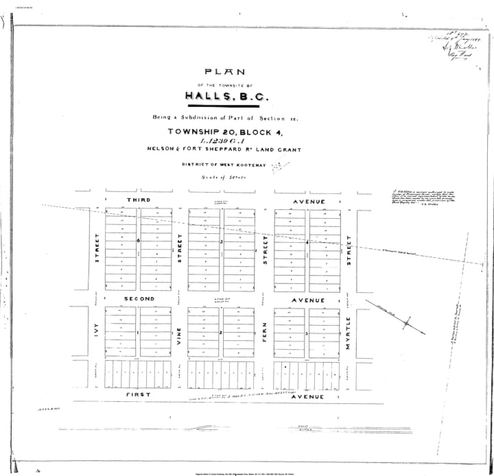
A townsite, known as Halls, was surveyed by O.B.N. Wilkie out of the original Nelson and Fort Sheppard land grant and deposited with the land registry on January 9, 1899. The streets were named Ivy, Vine, Fern, and Myrtle. Today only Ivy Street survives.
The Hall post office opened in 1898, closed in 1904, reopened in 1914, and closed again in 1925.
Hall Siding remains a small residential community. The name is preserved in Hall Siding Road.
Hall Landing and Healy’s Landing
These two places on the Duncan River might be one and the same, but it’s hard to say. The former’s namesake is unknown, but the latter is after John (Jack) Healy (often spelled Healey) a packer of supplies to mining camps and halfway house proprietor.
Healy also has a namesake creek that flows into the Lardeau River, first mentioned in the Nelson Miner of October 1, 1892: “It is reported that a prospector from Kaslo … has made a rich strike in the vicinity of the group of claims recently located by J.W. Haskins and others near the head of Healy creek.”
Hall Landing is first mentioned in The Kootenaian of August 17, 1899: “Passengers for Hall Landing leave Kaslo on steamer Hercules on Friday, proceeding to Duncan same afternoon by steamer Marion, leaving there on Saturday at 8 a.m. and arriving at Hall Landing at noon.
In 1900, John Healy applied for a liquor license at Hall’s Landing — not to be confused with another Hall’s Landing on Upper Arrow Lake, between Arrowhead and Revelstoke. In 1901, he applied for a renewal at “Hall Creek Landing.”
According to Maitland Harrison in Where the Lardeau River Flows, before coming to Canada Healy was a jockey in Ireland. He was lured across the ocean to ride for a “rich American,” but later set out on his own. Arriving in the Lardeau, “he built this little log house and got a bunch of horses and started the hotel. He had about five or six bedrooms, a living room, bar, dining room, and kitchen. It was rough and ready but beautiful.”
Around 1908, Jack’s niece Maude came out from Ireland to join him. The two grew their own food, hunted and trapped. “She’d cook and keep the place and he ran the horses,” Harrison recalled. “People would come up on the boat and they’d put them up at night and feed them. The next day Jack would take them up the valley with his pack train.”
The earliest mention of Healy’s Landing, which is about 12 miles (19 km) from Hall Creek, is in the BC government sessional papers of 1908. The first known newspaper mention is from The Ledge of July 17, 1913: “Owing to the extreme prevalence of mosquitoes along the Duncan river, work has been suspended for the summer on the trail between Healy’s landing and Hall creek.”
A late mention of Healy’s Landing appeared in the Chilliwack Progress of December 13, 1934.
Jack Healy was alive as of 1922, but it’s unclear when he died. Maude passed away in Kaslo in 1976, age 87.
Previous installments in this series
Applegrove, Appleby, and Appledale revisited
Bakers, Birds, and Bosun Landing
Bannock City, Basin City, and Bear Lake City
Bealby Point (aka Florence Park) revisited
Boswell, Bosworth, Boulder Mill, and Broadwater
Brooklyn, Brouse, and Burnt Flat
Camborne, Cariboo City, and Carrolls Landing
Carmi, Cedar Point, Circle City, and Clark’s Camp
Carson, Carstens, and Cascade City
Christina City and Christian Valley
Cody and Champion Creek revisited
Champion Creek revisited, again
Columbia City, Columbia Gardens, and Columbia Park
Crawford Bay and Comaplix revisited
Dawson, Deadwood, and Deanshaven
English Cove and English Point
Forslund, Fosthall, and Fairview
Fort Shepherd vs. Fort Sheppard, Part 1
Fort Shepherd vs. Fort Sheppard, Part 2
Gladstone and Gerrard, revisited