One hundred and fifth in a semi-alphabetical series on West Kootenay/Boundary place names
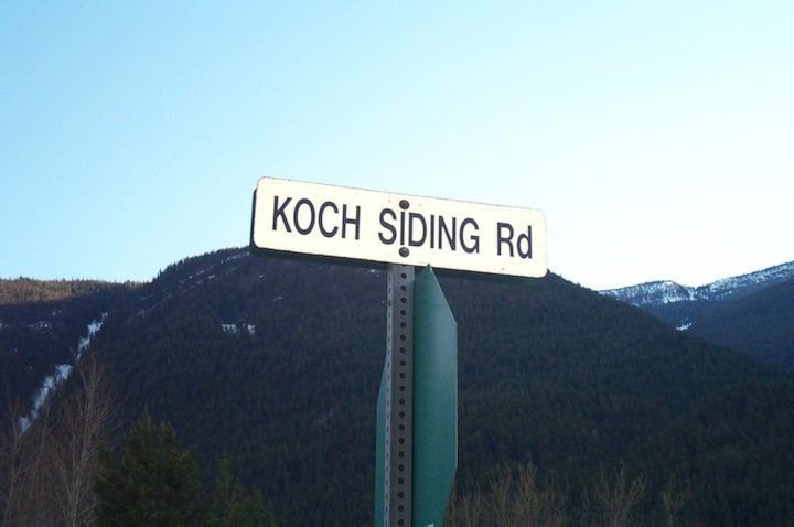
Koch Siding is the flat along the Slocan River below the Slocan Park cemetery. While today most people consider it part of Slocan Park, for a short while it was a distinct place.
It took its name after William Carl Earnest (Billy) Koch (1856-1931), an Ohio-born entrepreneur involved in mining, forestry, and cattle ranching. (His name rhymed with owe.) He arrived in West Kootenay from Colorado in 1896 and took a contract to haul ore from the east side of Slocan Lake. He also built a sawmill at Ten Mile Creek, and around 1906 established another mill at what became Koch Siding.
 When the Geographic Survey of Canada inquired about the name in 1909, Koch replied: “The CPR named it this and when it was made a regular railroad station and they had their tickets made or printed and all of their freight tariffs made out in this name, they did not care to change same, so when Mr. Breenlief, the post office inspector was in Nelson, and the name came up, he said it was best to leave it this name [or] it would conflict with CPR.”
However, the Koch Siding post office opened on Feb. 1, 1906 — before the name was added to the CPR timetable on May 6 of that year, although perhaps the CPR used it unofficially for a while. The post office moved to Passmore in 1923. (A rare Koch Siding postmark is seen above.)
Koch eventually sold his mill to the Doukhobors, who built a community hall with quarters for leader Peter (Lordly) Verigin, as well as a large barracks for mill workers. According to Jon Kalmakoff’s Doukhobor Genealogy Website, in 1928 Verigin’s son renamed the settlement Petrovka after himself, but it didn’t stick. Fruit and potatoes were raised at Koch (which the Doukhobors called Kov, a Russianization of the original name).
The name remains in limited use, thanks to Koch Siding Rd. and Koch Creek, but it bears few signs that it was once a bustling sawmilling and agricultural community.
William Koch moved to Nelson and died there.
KEEN
This siding on the Kaslo and Slocan Railway was named for Kaslo politician John Keen (1844-1922). For reasons unknown, it was originally called Adamant, and was included on the CPR timetable as of 1914.
Don Blake wrote in Valley of the Ghosts: “To call Keen a town would be like calling an apple seed an apple. It was really no more than a siding on the railway designed to serve the need of the mines in the 10 and 12 mile creek areas (between Kaslo and New Denver).”
The 1918 Wrigley’s directory of BC listed Adamant as “a flag station on the CPR Kaslo-Nakusp line.” It first shows up in the directory as Keen in 1923, so presumably it was renamed in posthumous tribute to John Keen.
The name survives in Keen Creek, formerly known as Mansfield Creek after mining promoter Ernest Mansfield (1862-1924). There’s also a Mount Keen in the Lardeau.
Previous installments in this series
Applegrove, Appleby, and Appledale revisited
Bakers, Birds, and Bosun Landing
Bannock City, Basin City, and Bear Lake City
Bealby Point (aka Florence Park) revisited
Boswell, Bosworth, Boulder Mill, and Broadwater
Brooklyn, Brouse, and Burnt Flat
Camborne, Cariboo City, and Carrolls Landing
Carmi, Cedar Point, Circle City, and Clark’s Camp
Carson, Carstens, and Cascade City
Christina City and Christian Valley
Cody and Champion Creek revisited
Champion Creek revisited, again
Columbia City, Columbia Gardens, and Columbia Park
Crawford Bay and Comaplix revisited
Dawson, Deadwood, and Deanshaven
English Cove and English Point
Forslund, Fosthall, and Fairview
Fort Shepherd vs. Fort Sheppard, Part 1
Fort Shepherd vs. Fort Sheppard, Part 2
Gladstone and Gerrard, revisited
Granite Siding and Granite City
Hall Siding and Healy’s Landing
Hudu Valley, Huntingtdon, and Healy’s Landing revisited
Inonoaklin Valley (aka Fire Valley)