One hundred sixteenth in a semi-alphabetical series on West Kootenay/Boundary place names
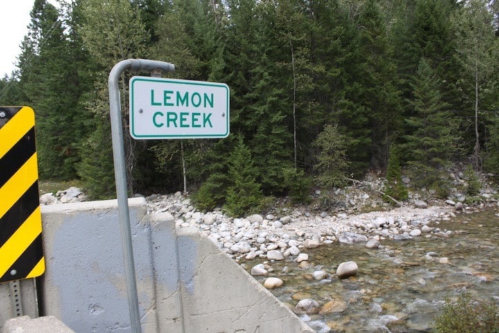
Lemon Creek is a prominent Slocan Valley waterway and community named for pioneer merchant Robert E. Lemon (1855-1907). That’s despite a sign along the rail trail that claims “Lemon Creek was so named because of the colour of the gold that was extracted from it.”
According to his biography in R.E. Gosnell’s History of British Columbia (1906), Lemon was born in Paris, Kentucky but as a young boy, his family moved to Wisconsin where he grew up on a farm.
Before arriving in West Kootenay, he had a peripatetic life that saw him teach school in Wisconsin and Colorado, work in a general store in Alabama, and run restaurants in New Mexico and Arizona.
He went to Puget Sound in 1884 and then came to BC and worked as a purser on the steamer Lady Dufferin, which plied the Shuswap River. The following year he opened a general store at Eagle Pass Landing, near Sicamous, and later moved to Rogers Pass Village and then Revelstoke.
In 1888, he ran the first flat boat down the Columbia River to Sproat’s Landing (near Robson) and built another store. He was also in business in Nelson, at first in partnership with J. Fred Hume, and later in Rossland, where he was the original owner of the Josie mine, named after his sister.
Lemon was appointed warden of the provincial jail in Nelson in 1901 and held the position until just before his death. Oddly, no photos of him are known to exist, although there are historical pictures of his stores at Rogers Pass Village and Rossland, the latter of which is still standing.
The earliest mention of the creek that bears his name is in the Nelson Miner of May 7, 1892: “A bridge over Lemon’s creek has been started and the trail will be completed to the lake within a week or two.”
Presumably the name acknowledged the fact Lemon was among the Nelson merchants who put up money to build the trail. But there was uncertainty whether it was a creek or a river. The BC government’s public works report for 1892 said: “The bridge over Lemon River is a substantial structure …” Perry’s Mining Map of 1893, however, called it Lemon Creek.
The area was home to a bewildering number of place names, including Summit, Lemonton, Lemon City, Lemon Creek Crossing, Lemon Creek Siding, Del Monte, and Oro — although those names actually applied to just three places. Next week we’ll start sorting them out.
Previous installments in this series
Applegrove, Appleby, and Appledale revisited
Bakers, Birds, and Bosun Landing
Bannock City, Basin City, and Bear Lake City
Bealby Point (aka Florence Park) revisited
Boswell, Bosworth, Boulder Mill, and Broadwater
Brooklyn, Brouse, and Burnt Flat
Camborne, Cariboo City, and Carrolls Landing
Carmi, Cedar Point, Circle City, and Clark’s Camp
Carson, Carstens, and Cascade City
Christina City and Christian Valley
Cody and Champion Creek revisited
Champion Creek revisited, again
Columbia City, Columbia Gardens, and Columbia Park
Crawford Bay and Comaplix revisited
Dawson, Deadwood, and Deanshaven
English Cove and English Point
Forslund, Fosthall, and Fairview
Fort Shepherd vs. Fort Sheppard, Part 1
Fort Shepherd vs. Fort Sheppard, Part 2
Gladstone and Gerrard, revisited
Granite Siding and Granite City
Hall Siding and Healy’s Landing
Hudu Valley, Huntingtdon, and Healy’s Landing revisited
Inonoaklin Valley (aka Fire Valley)
Jersey, Johnsons Landing, and Jubilee Point
Kootenay Bay, Kraft, and Krestova
Kuskonook (and Kuskanax), Part 3