One-hundred sixty-fourth in an alphabetical series on West Kootenay/Boundary place names
Robson honors BC’s ninth premier, John Robson (1824-92) (pictured below), although he never saw his namesake town.
Born in Perth, Ont., he came west in 1859 to join the Fraser Canyon gold rush, but struggled as a prospector. He settled in New Westminster and instead became editor of The British Columbian newspaper, which led him to frequent clashes with colonial governor Sir James Douglas.
Later, as political editor of Victoria’s Daily British Colonist, he advocated that BC join confederation, which came to pass in 1871. Robson was then elected to the first legislative assembly. He served in various cabinet posts and was appointed premier in 1889 upon the death of Alexander Davie. However, three years later, on a visit to London, Robson hurt his finger in a carriage door, which led to fatal blood poisoning.
 Robson had several other things named after him including Robson Cove, near the entrance to Burrard Inlet, and Robson St. in Vancouver.
In 1891, the CPR completed its Columbia and Kootenay Railway between Nelson and Sproat’s Landing — roughly where the Castlegar sewage lagoons are today — but soured on Sproat’s as the terminus. Probably this was because the low-lying land was prone to flooding, but one source claimed it was due to “exorbitant land grabbing by the occupants of the Sproat site.”
In any case, they eyed a different townsite upstream, first mentioned in the Nelson Miner of Dec. 6, 1890: “About 70 acres of the new townsite above Sproat has been cleared. The site is described as a good one, and, of course, is owned by the Canadian Pacific Railway.”
The name was revealed in the Miner of March 14, 1891: “The Canadian Pacific’s new townsite above Sproat has been named Robson, in honour of John Robson, premier of the province.” (The CPR undoubtedly chose the name in gratitude for the subsidies Robson’s government provided them.)
In a letter to the postmaster general dated June 1, 1891, postal inspector E.H. Fletcher wrote: “Robson, the western terminal of this [Columbia & Kootenay] railway is a new townsite which the CPR have established … When the regular train service commences the town of Sproat will be deserted … The hotels and stores are being moved to Robson and all those who will live there are making preparations to leave Sproat.”
The post office was soon authorized in anticipation of the closure of the one at Sproat’s Landing, but a suitable postmaster couldn’t be found, so it didn’t open until Aug. 1, 1892 — just over a month after John Robson’s death.
The steamer landing on the opposite bank of the Columbia River from Robson was called West Robson, first mentioned in the Brooklyn News of Aug. 6, 1898: “Her first work was to transfer the old Columbia & Western station from Trail to West Robson …” (Much later it became known as Robson West instead.)
The original Robson was called East Robson on CPR timetables and occasionally in newspapers, such as this early example from the Greenwood Miner of Oct. 13, 1899: “West Robson is mainly remarkable for being opposite East Robson, to which a ferry carries you safely.”
But it didn’t stick; East Robson eventually reverted back to just Robson.
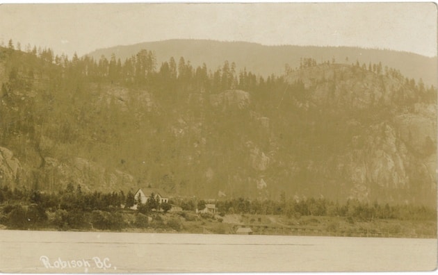
The original Robson townsite is off Broadwater Road, bounded by Waldie and Charleston avenues, but its southern boundary has been stretched to the point that its dividing line with Raspberry is no longer clear. For census and improvement district purposes, they’re combined as Robson-Raspberry.
The Robson post office closed in late 1893, reopened in 1894, closed again in 1902, and reopened in 1909.
A BC stop of interest sign was erected at Robson in 1970, paying tribute to its namesake, but it has long since gone missing.
Rock Creek
Rock Creek (one of five streams in BC with that name) is by far the oldest community in the Boundary. It was the site of a placer mining rush that began in October 1859 when Adam Beam discovered gold.
The name was first recorded in the Victoria British Colonist of July 14, 1860, which referred to the “newly opened mines on Rock Creek, in the Okanagan [sic] country.”
James M. Thorpe contributed a letter from the “Forks of Kettle and Rock Creek” dated June 25, while E. Crockett added: “A number of men have just arrived from Rock Creek … and give a glowing account of new diggings they have struck.”
A town sprang up, but by the late summer of 1862, the rush was over and the place almost deserted. Sporadic placer mining continued, but it wasn’t until 1886 that the town started coming back to life, following new gold discoveries.
The Rock Creek post office opened on June 1, 1888. A government townsite was reserved sometime before April 1897 on a site to the east of Rock Creek long occupied by Chinese vegetable gardens. Charles deBlois Green surveyed the site and an auction of lots was held in September, but only four sold.
A surveyor named C. Shaw deposited a revised plan on Oct. 5, 1911 which showed streets named Jubilee, Queen, Government, Victoria, and Diamond. Only Jubilee survives today, although not in its original configuration.
Another community developed about a mile south of Rock Creek known as Riverside, which we touched on last week. However, it’s since been subsumed by Rock Creek.
Below: The Rock Creek Hotel (which is still in business) is seen in a ca. 1940s postcard.

Previous installments in this series
Applegrove, Appleby, and Appledale revisited
Bakers, Birds, and Bosun Landing
Bannock City, Basin City, and Bear Lake City
Bealby Point (aka Florence Park) revisited
Boswell, Bosworth, Boulder Mill, and Broadwater
Brooklyn, Brouse, and Burnt Flat
Camborne, Cariboo City, and Carrolls Landing
Carmi, Cedar Point, Circle City, and Clark’s Camp
Carson, Carstens, and Cascade City
Christina City and Christian Valley
Cody and Champion Creek revisited
Champion Creek revisited, again
Columbia City, Columbia Gardens, and Columbia Park
Crawford Bay and Comaplix revisited
Dawson, Deadwood, and Deanshaven
English Cove and English Point
Forslund, Fosthall, and Fairview
Fort Shepherd vs. Fort Sheppard, Part 1
Fort Shepherd vs. Fort Sheppard, Part 2
Gladstone and Gerrard, revisited
Hall Siding and Healy’s Landing
Hudu Valley, Huntingtdon, and Healy’s Landing revisited
Inonoaklin Valley (aka Fire Valley)
Jersey, Johnsons Landing, and Jubilee Point
Kootenay Bay, Kraft, and Krestova
Kuskonook (and Kuskanax), Part 3
Labarthe, Lafferty, and Longbeach
Makinsons Landing and Marblehead
McDonalds Landing, McGuigan, and Meadow Creek
Meadows, Melville, and Miles’ Ferry
Mirror Lake and Molly Gibson Landing
Montgomery and Monte Carlo, Part 1
Montgomery and Monte Carlo, Part 2
Poupore, Powder Point, and Power’s Camp