Sixty-third in a series on West Kootenay/Boundary place names
There are two Fairviews in West Kootenay: the Nelson neighborhood, which we’ll deal with later in this series, and the subdivision on the west side of the highway between Genelle and Castlegar.
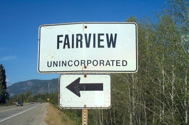
The Regional District of Central Kootenay’s earliest plan of the latter is from 1966. Its streets include 201st Avenue plus Jesse, Hetman, Fairview, and Poupore roads. (Poupore will also be taken up later in this series.) Its status as a community unto itself is thanks largely to a “Fairview Unincorporated” sign. It’s not recognized in the BC Geographical Names database.
Forslund
This sternwheeler landing south of Needles on the west side of Lower Arrow Lake was named for Capt. Albert Forslund (1864-1938) who arrived from Sweden in 1890. For many years he piloted the SS Rossland and Minto and also operated a large orchard and farm.
Fosthall
Fosthall is the name of a locality, bay, creek, point, and mountain on the west side of Upper Arrow Lake, northwest of Nakusp.
Its earliest use was in George Dawson’s Report on a Portion of the West Kootanie [sic] District, British Columbia, dated 1889: “At about 22 miles from the head of the lake, on the west side, Fosthall Creek comes in …”
In March 1907, A.H. Green and F.P. Burden surveyed the Fosthall “valley lands” for the Canadian Dominion Development Co. of Winnipeg. It didn’t amount to much, although a few attempts were made to plant fruit trees.
The name’s origin is a mystery.
In Pioneer Days of Nakusp and Arrow Lakes, Kate Johnson claimed Fosthall “gets its name from a clerk in the employ of the Hudson’s Bay post there in the early days of white settlement. Foundation timbers of old buildings were seen around 1890 between the present house and the creek at the south need of the bay.”
Unfortunately, Johnson didn’t provide any sources, and in First Nations Ethnography & Ethnohistory in BC’s Lower Kootenay/Columbia Hydropower Region, Dorothy Kennedy and Randy Bouchard say they were unable to find any reference to a post at that location or any employees named Fosthall in Hudson’s Bay Company’s records. (The late Bill Laux suggested there may have been a trading post there that didn’t belong to the company.)
Fosthall, by that spelling at least, is a very rare surname.
Kennedy and Bouchard noted that on an 1866 map, surveyor Walter Moberly gave the name of Fosthall Creek as naghtuous, while two years later, James Bissett, a chief trader with the Hudson’s Bay Company, recorded it in his diary as nauchteaux, “which clearly are attempts to transcribe the same indigenous name.” They believed it was an Okanagan-Colville term derived from n7axwt meaning “downstream; go downstream.”
Previous installments in this series
Applegrove, Appleby, and Appledale revisited
Bakers, Birds, and Bosun Landing
Bannock City, Basin City, and Bear Lake City
Bealby Point (aka Florence Park) revisited
Boswell, Bosworth, Boulder Mill, and Broadwater
Brooklyn, Brouse, and Burnt Flat
Camborne, Cariboo City, and Carrolls Landing
Carmi, Cedar Point, Circle City, and Clark’s Camp
Carson, Carstens, and Cascade City
Christina City and Christian Valley
Cody and Champion Creek revisited
Champion Creek revisited, again
Columbia City, Columbia Gardens, and Columbia Park
Crawford Bay and Comaplix revisited
Dawson, Deadwood, and Deanshaven
English Cove and English Point
Fort Shepherd vs. Fort Sheppard, Part 1