Seventy-fourth in an alphabetical series on West Kootenay/Boundary place names
Gold! The word alone makes a prospector salivate.
Shortly after the turn of the 20th century, the Lardeau had two places with golden names.
Goldfields, a mile above Camborne, was first mentioned in the Lardeau Eagle of October 24, 1901: “Now comes G.F. Goldsmith with a rival for Camborne. The new townsite is Goldfields … Mr. Goldsmith recently purchased from Roger E. Perry an interest in the townsite and with Mr. Perry will proceed to slash timber and lay out streets, survey and plot the ground at once. Messrs. Goldsmith and Perry have the making of a splendid townsite at Goldfields, adjoining as it does the famous Camborne group …”
George Goldsmith lacked the Midas touch, however. Henri Robideaux writes in Flapjacks and Photographs that the town owned by “the most fastidious prospector in the Lardeau … was a failure, as nearby Camborne had already established itself as the saloon center for the Fish Creek camp.” He is remembered, however, in Mount Goldsmith, adjacent to Goldfields.
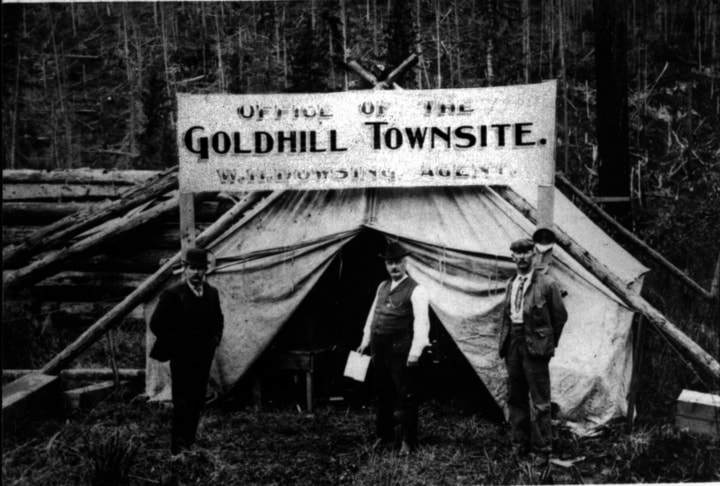
Slightly more successfully was Gold Hill, near Poplar. Also spelled Goldhill, it was originally known as Second Crossing, for it was the second place the railway crossed the Lardeau River.
Here Edward Mobbs of Gerrard envisioned a metropolis to serve the gold rush of 1903-04, to which he gave an unusual name. The Ledge of September 3, 1903 reported: “E. Mobbs has a townsite called Uto, at the Second Crossing near Poplar. Near it some Swedes have a property which they value at $50,000. The location for a town in the fine gold belt is very desirable and Uto should soon be a hummer.”
There is still an Uto Glacier and Peak in the Sir Donald range of Glacier National park, which according to Canadian Mountain Place Names mountaineer Charles E. Fay named for the section of the Swiss Alpine Club that fellow climbers Carl Sulzer and Emil Huber belonged to. The pair reached the top of Uto Peak in 1890.
However, the townsite was renamed by October 1903, when the Mining Record stated: “Second Crossing is about three miles south of Poplar, and here the townsite boomer is trying to ‘get in his work,’ for already the new townsite named Goldhill is being advertised …”
W.D. Mackay surveyed the Gold Hill townsite on December 4, 1903 and deposited it with the land registry on May 19, 1904. A post office operated from July 1904 to May 1906. When the boom died down, so did the town, although the name is still in limited use.
When the CPR arrived near present-day Revelstoke in 1885, it squabbled with surveyor Arthur Farwell, who laid out a townsite there and named it after himself, anticipating the railway would cut through his land. The company built a small, temporary station there known both as Second Crossing and Gold Hill before platting its own townsite to the east, which became Revelstoke.
Previous installments in this series
Applegrove, Appleby, and Appledale revisited
Bakers, Birds, and Bosun Landing
Bannock City, Basin City, and Bear Lake City
Bealby Point (aka Florence Park) revisited
Boswell, Bosworth, Boulder Mill, and Broadwater
Brooklyn, Brouse, and Burnt Flat
Camborne, Cariboo City, and Carrolls Landing
Carmi, Cedar Point, Circle City, and Clark’s Camp
Carson, Carstens, and Cascade City
Christina City and Christian Valley
Cody and Champion Creek revisited
Champion Creek revisited, again
Columbia City, Columbia Gardens, and Columbia Park
Crawford Bay and Comaplix revisited
Dawson, Deadwood, and Deanshaven
English Cove and English Point
Forslund, Fosthall, and Fairview
Fort Shepherd vs. Fort Sheppard, Part 1
Fort Shepherd vs. Fort Sheppard, Part 2