Touchstones Nelson has no shortage of historical maps and images, and sifting through piles of them in the archives can be quite a time-consuming task. But recently Nelson resident Doug Jones asked for permission to give them a look, and now four digitally enhanced archival images have been made available for sale.
“Without public interest or the interest of the community in the items we preserve downstairs, these images wouldn’t be available and we wouldn’t be able to do what we do,” said Laura Fortier, collections manager for Touchstones.
Fortier said Jones approached them about finding local images that he could design and sell in a partnership between Cartolina and Touchstones.
“He was able to find some real gems,” said Fortier, noting that Touchstones doesn’t have the technology necessary to do the sort of scanning and digital editing work Jones did on the images.
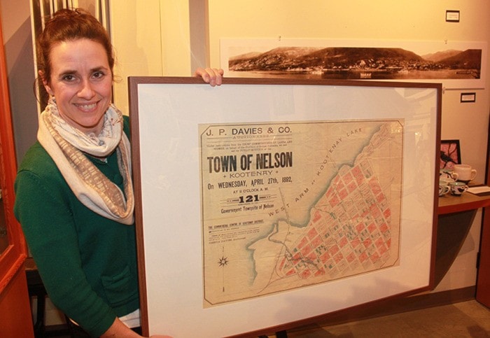
The four prints include an 1892 map of Nelson, two topographical maps of the Kootenay area and a blueprint of the S.S Bonnington, which originally serviced Arrow Lakes.
“These are just a fraction of what we have in the archives. Altogether we’ve got four finalized, and two more in the works,” said Fortier.
She expressed hope the project would continue.
“These beautiful images wouldn’t be getting out in the public if it wasn’t for Doug’s interest. We’re hoping for a nice long-term partnership,” she said.
Visitor services manager Cindy Fillion said the topographical maps have been especially popular for women shopping for their husbands and boyfriends.
“They may work in an office building, but they dream of being outside hiking, skiing, being outdoors,” she said.
“This is a nice, historic piece of artwork that reminds them of the outdoors.”
But you shouldn’t use them for navigation or consider them accurate, exactly.
“With the topography it was a lot of guess work, because we didn’t have satellites or planes to get aerials. Doug said when they didn’t really know what was behind a certain area, that’s what they drew,” she said, motioning toward cross-hatched shaded areas.
“Even so, it’s pretty impressive how accurate they are.”
And though Nelson hadn’t even be incorporated yet, the 1892 map already shows many of the streets and landmarks residents are familiar with today.
Fortier said the reaction to the new prints has been overwhelmingly positive.
Touchstones Nelson is open Wednesday to Saturday 10 to 5 p.m. and Tuesday to Sunday 11 a.m. to 4 p.m.
For more information call Touchstones Nelson at (250) 352-9813.