From where Kootenay resident Bob Tremblay was sitting in his backyard along Highway 3A, surrounded on all sides by sprinklers, he could watch as a raging forest fire slowly made its way down the slope towards his home. The conflagration, which is visible from the big orange bridge in Nelson, has prompted evacuation alerts in the area.
But as of 11:45 p.m., he hadn't heard anything. "I don't know how they contact you in situations like this. I think they resort to going door to door."
In the meantime, he was enjoying the view and trying not to panic.
"Right now we're looking up into the Aerie Creek drainage, looking northwest, and it's one tremendous fire burning here," said Tremblay, whose wife Joyce was also watching with concern. The pair plan to retreat to an empty field across the highway if things worsen.
"We're getting the Okanagan's 2003 series here," said Tremblay. "It is cooling off a bit, and they'll be out there at first light but there it is, coming down the hill."
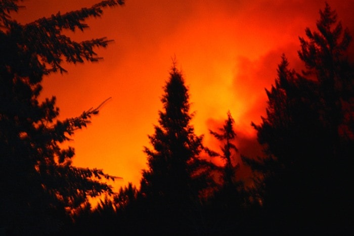
From where the Star joined him, the fire conjured up visions of Hell as it painted the sky in deep oranges and blood-reds.
Occasionally a specific tree would light up, which Tremblay called "candling".
Residents were hurriedly driving back and forth along the highway, collecting along the shoulders to take pictures while police urged residents to move along.
The Regional District of Central Kootenay's emergency centre has has imposed an evacuation alert.
Residents who live in the area between Sitkum Creek South and Willow Point (Six Mile Lakes Road) have been urged to be aware of the alert as a precautionary measure.
The fire is estimated to have immersed 60 hectares in flame. It may have been caused by the tree-toppling storm in Nelson earlier this week.
"Scary how fast this thing is moving. It's burned 2-3 km in the past 4 hours," posted resident John Paolozzi on Facebook. "I feel a little sick watching this thing."
Many others posted photos and videos, some juxtaposed against the matching orange of the bridge.
"It's devouring the hillside," wrote Jason Peil.
Photographer Courtney Thompson shared a photo with the Star that she took Sunday evening (above) in which the blues and purples of the surrounding area are contrasted against the smoky ridgeline above Tremblay's home and Kootenay Lake.
"Keep safe out there everyone, things just got real," she wrote as a caption.
"I'm up watching from my deck behind Nelson Toyota," she said. "It's sure moving over that ridge."
She said the experience escalated over the course of the day.
"I started watching this fire this afternoon from out on the water. Things looked like they had died down a bit earlier in the evening. Around 8:30 p.m. you could tell that the fire was starting to gain strength and move down the hill a bit faster. I hopped in the truck up Give Out Creek to see if I could get a better vantage point by late this evening to try and grab some shots."
Photographer Adrian Wagner also posted a shot (below) at midnight.

Others offered up their houses for displaced residents, and encouraged people to stay safe. There are approximately 350 residents in the impacted area.
Local minister John Thwaites had a simple message, upon seeing the news.
"Please pray," he said.
To learn about evacuation procedure and how to be prepared if the fire spreads, visit http://www.readyforwildfire.org/pre-evacuation_preparation/.
To keep track of the fire's status, visit bcwildfire.ca.
This story will be updated. Please send any personal accounts, pictures or videos of the fire to reporter@nelsonstar.com


