On April 7, Nelson city council went part way toward approving a number of zoning changes for the proposed mixed-use residential development at Nelson Landing. This was for a different section of the development than the changes that made the news last year.
The next step will be a public hearing, not yet scheduled. After that, council will make a final zoning decision.
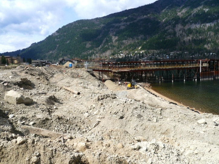
Nelson Landing is a mixed commercial-residential development of 265 housing units proposed to be build by the Storm Mountain Development Corporation on the old Kootenay Forest Products site on the shore of Kootenay Lake.
The development will be phased in over ten years, and if 40 housing units have been built by then, the phase-in period will be extended to 20 years.
First phase under construction
Phase 1 of the development, which will consist of eight housing units to be priced at around $400,000, is currently under construction.
The land on which Phase 1 is located was already zoned residential when Storm Mountain acquired the property. Last year council approved, after some public controversy, a number of variances for Phase 1 which essentially allowed the developer to put more units in a smaller space.
Rezoning the rest of the property
Now the developer has applied to rezone for the rest of the property, and this will also involve some amendments to the Official Community Plan. The city planning department and the developer want to scrap the mix of five zoning designations that were already there and replace them with the designation Comprehensive Development 5, and they have divided that into three physical areas: Area V, Area W, and Area W1, each with different requirements.
Area V
Area V is just west of Phase 1 of the development and it includes a large metal structure left over from the old lumber mill site. That structure will be incorporated into a public marina and dock. The area will also house a 40-unit hotel, office space, and retail space.
“This area is meant to be a village, not a through street,” city manager Kevin Cormack told council.
Areas W and W1
Area W is the narrow part of the property running up the lake from the Phase 1 development. The main zoning attributes of that area will be the reduced front and rear setbacks and increased building height already approved in the Phase 1 variances, and reduced parking for care facilities.
Area W1 begins where the property, further east, widens out, and is designated as a “pocket neighbourhood.” This neighbourhood will be zoned for more density, minimum lot area, and a maximum of 22 building units.
The city council document describing the pocket neighbourhood states that this “smaller footprint (will mean) a more efficient use of land, and potential reduction in housing costs provides for a variety in housing forms.”
Other zoning details
Other proposed changes to existing zoning applying to all areas of the development include:
- increased residential density to 265 units from a previously proposed 200,
- increased lot coverage to 55 per cent,
- minimum frontage on street reduced to 12 metres
- increased amenity space including the provision of a waterfront pathway and Red Sands beach reduction of road width to 7 metres
- reduction of sidewalk width to 1. 5 metres
- reduction of driveway width to 3 metres
- allowing permeable surface for the pathway,
- reducing waste and recycling containers to to 4 for entire site, and
- twenty parking stalls provided in designated pullouts but no parking on the road.
Collaboration between city planners and the developer
The plans for the rezoning that were presented to council on April 7 were the result of discussions over the past months between Storm Mountain and city planning staff.
“Management staff is trying to apply the Official Community Plan here,” Cormack told council. “So these are the results of negotiations.”
Council votes in favour—for now
Council discussed the proposed changes in some detail but had only a few concerns.
Councillor Anna Purcell wondered if the development would create a colourless enclave that would act as a barrier to the public's access to the waterfront, but she said she had no concrete reason for wondering this.
Councillor Michael Dailly wondered why the development had to be phased in over such a long period of 20 years. Cormack explained that it is a complex development requiring remediation of contaminated land and that the developer will be contributing a waterfront retaining wall and pathway and that it is therefore best seen as a long-term investment.
And Councillor Janice Morrison said that if carefully phasing it in over time would ensure a quality development she was all for it because, “the KFP land has lain fallow for so many years.”
Cormack said the developer will sign a Phased Development Agreement with the city that will govern the timelines over the ten or twenty year period.
Councillor Robin Cherbo said he was concerned about increased traffic on John's Walk.
“There were no major red flags,” Mayor Deb Kozak said in an interview later. “This project has been in the making for years, and this newest developer has been taking some time to figure out how things are going to fit on the waterfront.
“We went to community consultation around the waterfront master planning process,” she said, “and this is part of the master plan. The details of how it looks, we can discuss those, but this is what we envisioned for the waterfront-- the community envisioned it, not just council.”
Council approved the proposed zoning changes for first and second reading, paving the way for a public hearing sometime soon, and then a final vote.