Nelson could be on its way out of the BC Southern Interior riding.
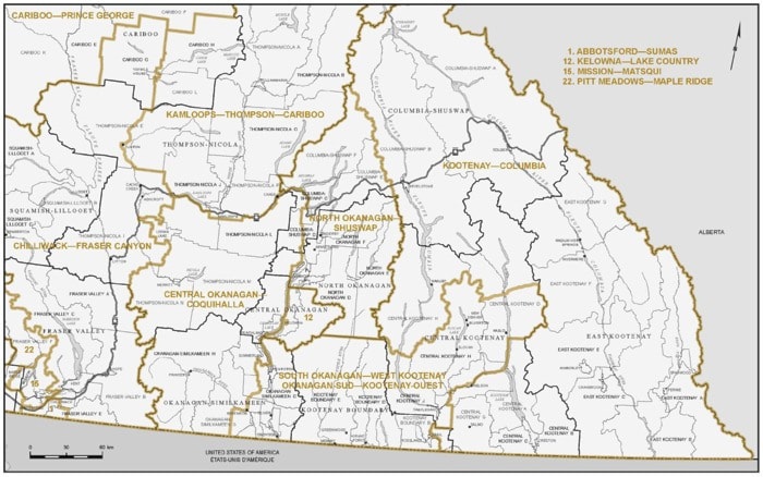
Last week the Federal Electoral Boundaries Commission for British Columbia proposed a new electoral map for consideration at public hearings taking place this fall. British Columbia is gaining six electoral districts as a result of the increase in its population.
The proposal takes into account British Columbia's increase in population from 3,907,738 in 2001 to 4,400,057, as captured in the 2011 census.
In the proposed map, Nelson would be bumped to the Kootenay-Columbia riding which runs all the way to the Alberta border and north past Revelstoke. Nelson would be on the extreme west edge of the new riding which would end near the city limits and not include the entire Regional District of Central Kootenay.
Nelson would also be in a different riding than Castlegar and Trail, but would remain in the riding with Salmo and Nakusp (see below for exact specifications as laid out in the report).
The riding to the west would be known as South Okanagan-West Kootenay. It would bring Penticton in and Princeton (currently in the BC Southern Interior) would be out.
The three member commission is made up of the Honourable John E. Hall, chair, Stewart Ladyman and Dr. J. Peter Meekison.
In addition to looking at population numbers, the commission focused on historical patterns and community of interest or identity to achieve the goal of effective representation in Parliament.
Under the Electoral Boundaries Readjustment Act, the commission's main aim in redrawing boundaries is to divide the province into electoral districts as close to the average population as reasonably possible.
The commission will now travel the province to gather input. It will be in Nelson on October 2. Those wishing to make a presentation must submit and information the commission by August 30.
For more information head to the commission website.
Make up of the proposed Kootenay-Columbia federal riding (population 109,058)
Consisting of:
- ( a ) the Regional District of East Kootenay;
- ( b ) those parts of the Regional District of Central Kootenay comprised of:
(i) the villages of Nakusp and Salmo;
(ii) the Town of Creston;
(iii) subdivisions A, B, C, G and K;
(iv) the City of Nelson;
(v) that part of Subdivision D lying northerly of a line described as follows: commencing at the intersection of the southwesterly production of Cooper Creek with the westerly limit of Subdivision D; thence generally northeasterly along said production and said creek to the Duncan River; thence northerly along said river to Hamill Creek; thence generally northeasterly along said creek to a point at latitude 50°16'55"N and longitude 116°35'50"W; thence easterly in a straight line to the easterly limit of said subdivision;
(vi) that part of Subdivision E lying southerly of the Kootenay River;
(vii) those parts of Subdivision F comprised of:
a. that part lying southerly of a line described as follows: commencing at the intersection of the westerly limit of Subdivision F with Highway No. 3A+6; thence generally northeasterly along said highway to the southeasterly limit of said subdivision;
b. that part lying easterly and southerly of a line described as follows: commencing at the intersection of the southerly limit of Subdivision F (Kootenay River) with the southerly projection of Grohman Creek; thence generally northerly along said projection and Grohman Creek to a point at approximate latitude 49°31'03"N and longitude 117°19'59"W; thence easterly in a straight line to the northwesterlymost point on the limit of the City of Nelson;
(viii) that part of Subdivision H lying easterly and southerly of a line described as follows: commencing at the intersection of the southerly limit of said subdivision with Highway No. 3A; thence generally northerly and easterly along said highway and Highway No. 3A+6 to the easterly limit of said subdivision;
- ( c ) that part of the Columbia-Shuswap Regional District comprised of: the City of Revelstoke; the Town of Golden; subdivisions A and B; and
( d ) that part of the Regional District of Kootenay Boundary comprised of Subdivision A and the villages of Fruitvale and Montrose.