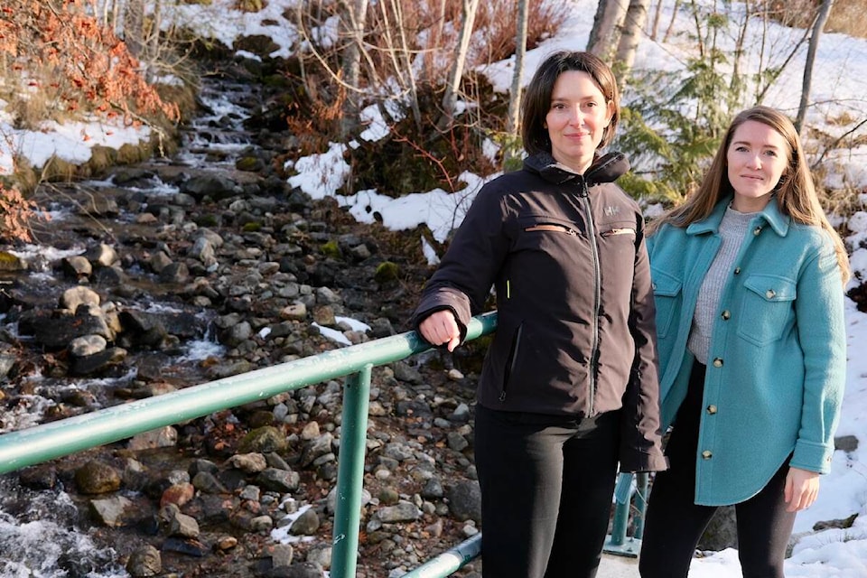
Anderson Creek could cause serious flooding in Fairview with significant damage to properties, according to an engineering report presented to Nelson council on Sept. 17.
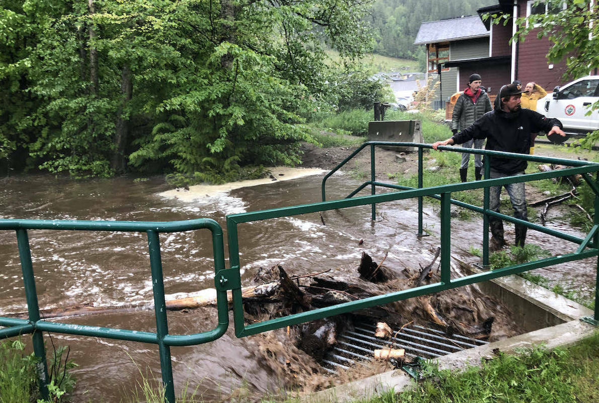
The report states that the creek’s culverts don’t have the capacity to handle large amounts of floating debris or excess sediment and the stream is confined to a “narrow artificial channel with insufficient erosion control.”
In the event of a serious flood, “very high economic damages could be expected.”
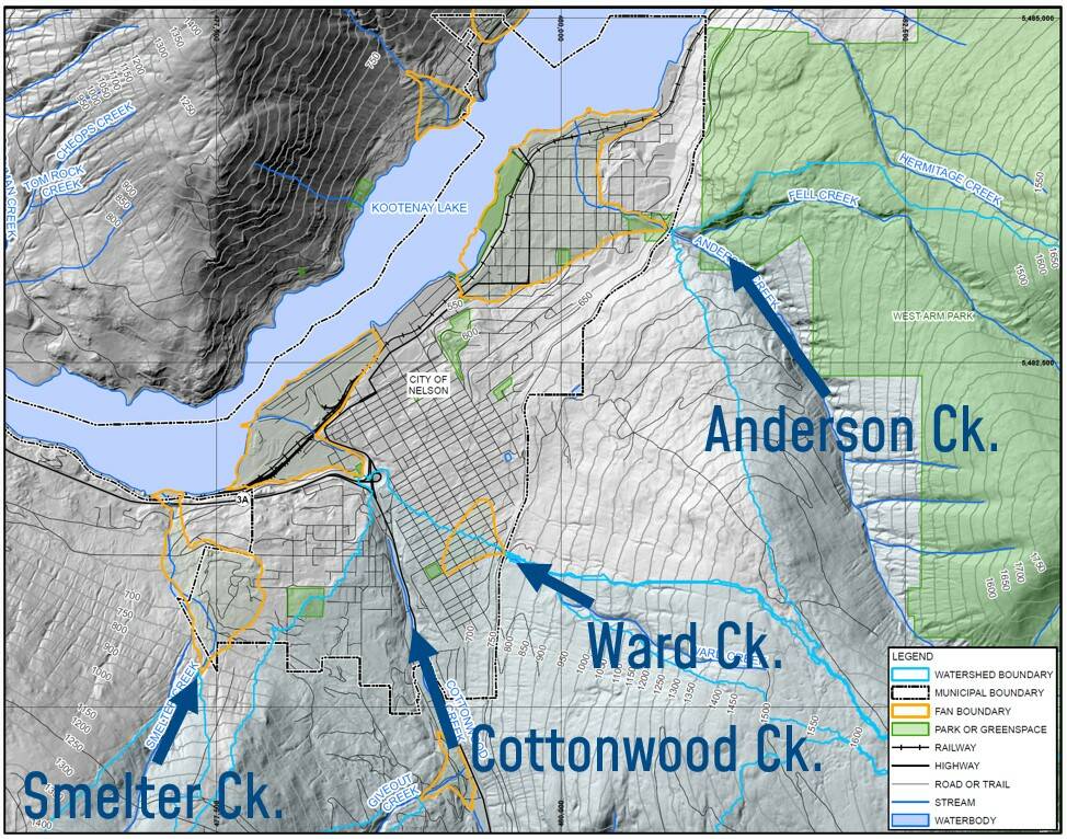
The report, entitled Steep Creeks Hazard Assessment Summary, was prepared for the city by BGC Engineering Inc. In addition to Anderson Creek, the report addresses Cottonwood, Giveout, Ward, Five Mile and Selous Creeks. But it places Anderson Creek as the highest risk, partly because it flows through a residential part of the city.
The report defines a steep creek as one that has an average slope of more than three degrees, or more than a five per cent grade.
In the event of a flood in Anderson Creek, the report states, “water and debris would flow down grade, preferentially following roads due to lower flow resistance. Downward sloping driveways could direct water and sediment towards garages and homes.”
BGC engineer Lauren Hutchinson told council that a debris flood on Anderson Creek could also cause erosion on both public and private land.
“Given the level of development on Anderson Creek,” Hutchinson said, “we prioritized it as high potential economic risk and we recommend detailed hazard and risk assessment to better understand and manage the potential risks.”
Such an assessment, she said, would include the creation of a map to govern land-use decisions, a more detailed estimate of life risk and economic risk, engineering options for reducing the danger, and policy changes.
At the Jan. 17 meeting, council voted unanimously to do that work on Anderson Creek, and to apply by a Feb. 24 deadline for a grant from the Community Emergency Preparedness Fund at the Union of BC Municipalities to fund it.
“Steep creek hazards such as floods, debris flows, and debris floods pose considerable risks to mountain communities and infrastructure,” said the city’s senior planner Natalie Andrijancic.
“Steep creeks can impact pedestrians, vehicular traffic, and residents, particularly during periods of heavy rainfall or snowmelt. These hazards can also pose a risk to development and infrastructure, as erosion and debris accumulation can cause damage to roads, buildings, and other structures.”
Andrijancic said addressing the possible effects of steep creek flooding is consistent with Nelson Next, the city’s climate plan, because this work will build resilience to climate change.
Cottonwood and other creeks
The BGC report states that Cottonwood Creek presents the risk of erosion and a debris flood that could undermine Highway 6. The creek’s tributaries, Giveout, Selous and Gold Creeks, are important because they influence the downstream behaviour of Cottonwood Creek.
In her presentation, Hutchinson referred to a small community of mobile and manufactured homes near the mouth of Giveout Creek. She said such structures are less resilient than wood frame houses, and she pointed out that there is an almost 90 degree intersection between Giveout and Cottonwood Creeks at Highway 6, with very little storage area for an accumulation of debris. A flood could result in the damming of Cottonwood Creek.
“And so we’ve identified that there is potential high life safety risk on Giveout Creek.”
Clearcut logging in the Giveout Creek drainage is also implicated in the danger.
“Historic instabilities in the watershed associated with logging have been reported,” the report states.
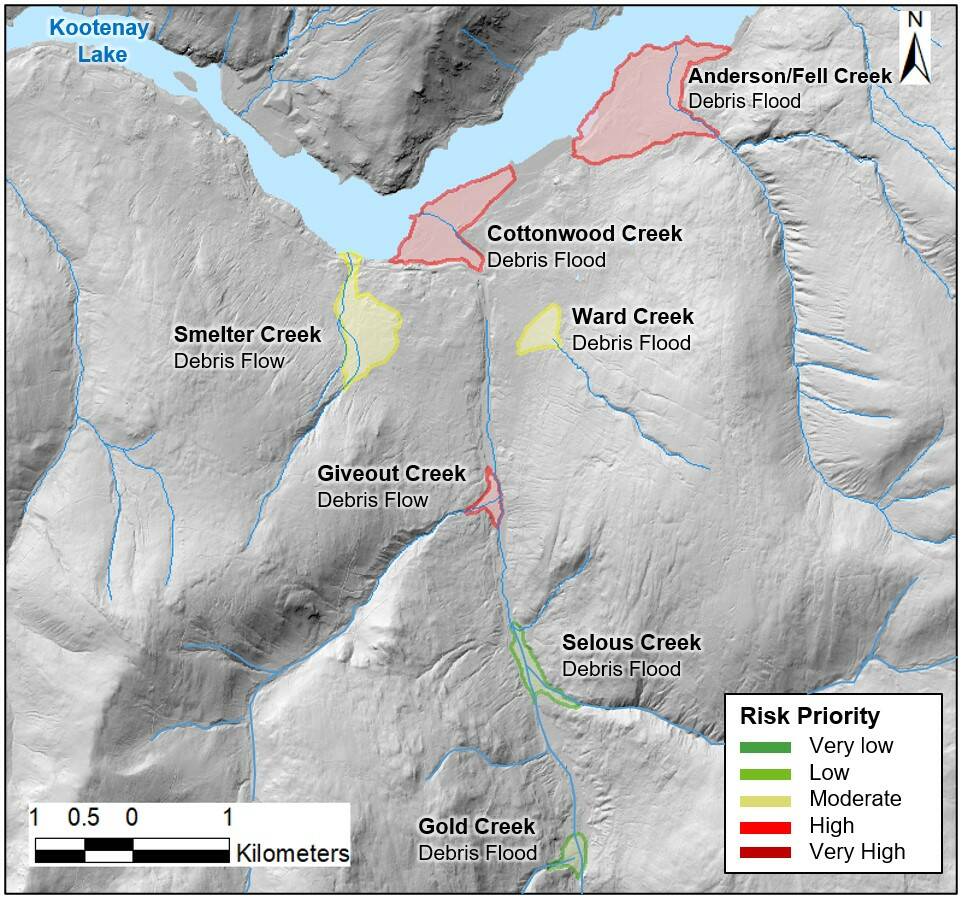
Ward Creek and Smelter Creek were also identified as needing further study but with lower priority. Smelter Creek runs west of the golf course and crosses several streets on its way to the Kootenay River, and should be evaluated for risk if more housing development is planned in its drainage. Ward Creek, which enters a storm drain in the vicinity of Fort Sheppard Drive, should be evaluated for its culvert sizes and the potential for damage to the rail trail.
Five Mile Creek, which supplies most of Nelson’s water, is located outside the municipal boundary and was therefore not considered in the BGC report, although the report states the creek may warrant further evaluation.
Questions from council
Councillor Jesse Woodward asked how residents are warned of an imminent flood, and if a certain water level automatically triggers a public warning.
John Topolovec, the city’s emergency management co-ordinator, replied that there is no such warning system in place and that the city relies on visual inspections. BGC’s Holm said that a system could be created in which specific flow rates would trigger emergency procedures.
Councillor Rik Logtenberg asked if green infrastructure (such as forests, wildlife habitat and ecosystems) are counted when engineers are assessing flood risk. Holm said this is increasingly being done in many municipalities. He said this would involve a public conversation to identify the key risks that the community cares most about.
Logtenberg also asked how a wildfire in a drainage such as Ward Creek would impact the estimate of flood risk for that creek.
Holm replied that a fire would increase the possibility of erosion, but it would help if a baseline flood risk assessment, such as the one being proposed, had already been done.
“You would be at least part way through a post-wildfire risk assessment before the fire. Nelson might like to think about this for Ward Creek, because a wildfire in that basin would change the game in terms of the level of hazard.”
Hutchinson added that BC Wildfire Service has done “future probability burn forecasting” for the province, and that the company would consider this in any further risk assessments.
Councillor Keith Page wondered how soon the city might have a creek inspection policy to guide when and where the creek is monitored.
Andrijancic said public works staff inspect the creeks during freshet or heavy rainfall. She later told the Nelson Star that a creek inspection policy has been included in this year’s plan for the city’s public works department and will be completed by the end of the year.
She said inspection is difficult because the creek runs through, or adjacent to, private properties without easements or rights of way, “so it is challenging because not everybody is keen to have staff going through their property to look at the creek.”
Holm told council that the need for local awareness of flooding hazards started with the Johnsons Landing slide in 2012 in which four people died. BGC was subsequently hired by the Regional District of Central Kootenay to evaluate district-wide flood risk. As a result, 16 high risk areas in the region (none in the City of Nelson) were identified with detailed maps and information.
READ MORE:
• Flooding: Why the RDCK ordered hundreds of properties evacuated
• One year after disastrous B.C. flooding, fear of new climate disasters loom
• New report outlines how to protect Nelson’s water sources
• Regional flood and geohazard risk assessment will help reduce the impact of disasters
• RDCK receives flood assessment funding
• Nelson council approves climate change plan
bill.metcalfe@nelsonstar.com
Like us on Facebook and follow us on Twitter